Le retour de Donald Trump à la tête de la présidence des États-Unis s’est accompagné de revendications impérialistes considérées comme inédites. Pourtant, l’intérêt des États-Unis pour le Groenland ne date pas du 2ᵉ mandat du milliardaire. Les prétentions, offres d’achat et volontés de prendre possession du Groenland ont été nombreuses au cours de l’histoire : 1868, 1946 et 2019, avec Donald Trump qui tente déjà un rachat. Revenons sur la première tentative, en 1868, formulée par William H. Seward, tentative qui n’a pas abouti mais qui a posé les bases d’une idée à laquelle les États-Unis n’ont jamais complètement renoncé.
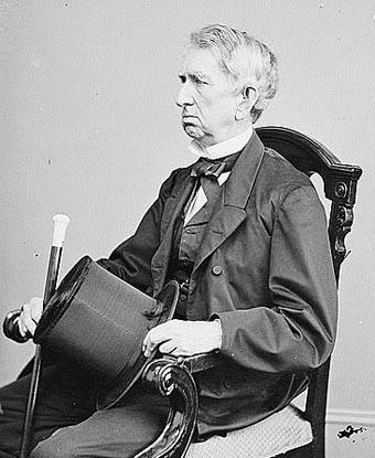
William Henry Seward est né à Florida, New York, le 16 mai 1801 et est décédé en 1872. Il est diplômé de l’Union College de Schenectady, New York en 1820. Membre du Parti Whig (droite libérale), il participe à la fondation du Parti Républicain en 1854. Beaucoup le considèrent à l’époque comme le meilleur candidat républicain à la présidence en 1860, mais c’est finalement Abraham Lincoln qui devient Président. Seward est finalement nommé secrétaire d’État par Abraham Lincoln, le 5 mars 1861. En 1865, il échappe à une tentative d’assassinat, parallèlement à celle de Lincoln qui est fatale à ce dernier. En dépit de ses blessures et du choc, Seward reste en fonction jusqu’au 4 mars 1869. Il gère les affaires internationales pendant la guerre civile et il se distingue en négociant l’achat de l’Alaska en 1867. C’est dans ce contexte que se situe sa réflexion concernant le Groenland (mais aussi par extension le Canada).
En 1868, alors que les États-Unis pansent encore les blessures de la guerre de Sécession et entament une période de reconstruction et d’expansion, William H. Seward, figure tutélaire de la diplomatie américaine, rédige un rapport dont la portée stratégique dépasse largement son époque, comme l’illustrent les prises de position de Donald Trump à propos du Groenland. Secrétaire d’État sous les présidences d’Abraham Lincoln et Andrew Johnson, architecte de l’achat de l’Alaska en 1867 – il est d’ailleurs, à ce titre, souvent raillé à l’époque comme le « frigidaire de Seward » –, il propose ici par ce rapport remis au Président Johnson, bien plus qu’un simple inventaire géographique : un projet géopolitique ambitieux.
Afin de comprendre la vision géopolitique développée par Seward, plusieurs points sont à souligner dans ce texte :
-Une vision continentale à long terme
Le document transcende la simple description scientifique. Il constitue une véritable doctrine d’expansion territoriale et maritime, annonçant ce que les historiens nommeront plus tard la « doctrine de la destinée manifeste » des États-Unis. Seward perçoit déjà le potentiel stratégique du Grand Nord : ressources minières, routes maritimes, zones de pêche, positionnement géopolitique.
Son analyse est remarquablement prospective pour l’époque. Alors que le monde occidental considère ces territoires comme des espaces inhospitaliers, voire inutiles, Seward y discerne des opportunités de développement économique et de puissance. Rappelons aussi qu’à cette époque, aucune considération écologique n’est, bien entendu, envisagée.
– Une stratégie face à la Grande-Bretagne incluant la question canadienne
Le rapport s’inscrit dans une logique de containment de l’influence britannique en Amérique du Nord. L’achat projeté de l’Islande et du Groenland viserait à « flanquer » le Canada, à réduire son espace de manœuvre et à l’inciter à rejoindre l’Union américaine. Le lecteur comprendra ainsi d’où viennent les prétentions de Donald Trump sur le Canada actuellement.
-Une vision moderne des ressources
Seward est l’un des premiers penseurs politiques à comprendre la valeur des océans comme réservoir alimentaire et économique. Sa réflexion sur les pêcheries, la reproduction marine et les potentialités alimentaires est d’une modernité saisissante, anticipant les enjeux contemporains de sécurité alimentaire et d’exploitation des ressources marines.
-Un document fondateur
Bien que le projet d’acquisition ne se soit jamais concrétisé, ce rapport demeure un texte fondamental pour comprendre la pensée géopolitique américaine de la fin du XIXe siècle. Il illustre la capacité visionnaire de Seward, qui voyait au-delà des frontières immédiates pour penser l’expansion sur le temps long. Les intuitions de Seward ne sont pas restées lettre morte. La stratégie américaine du XXe siècle – contrôle des routes maritimes, projection de puissance dans l’Arctique, valorisation des ressources nordiques – trouvera ses racines dans cette réflexion prospective.
Le rapport Seward n’est donc pas qu’un rapport administratif, mais un véritable manifeste géopolitique, témoignant de l’ambition intellectuelle et stratégique des dirigeants américains de l’époque.
Nous avons choisi de vous le proposer en intégralité.
Note : les commentaires de Cliotexte ne valent pas pour approbation de la vision développée par Seward et Trump. Les commentaires visent à donner des explications sur la vision géopolitique développée par les deux hommes politiques, le contexte global dans lequel s’inscrivent, les revendications de Donald Trump et les origines de son discours, éloignées en grande partie des réalités actuelles, en particulier en ce qui concerne l’environnement, le droit international, et surtout le droit des peuples à disposer d’eux-mêmes.
Version française ( traduction personnelle)
Washington, 24 avril 1868
MONSIEUR,
Lorsque vous m’avez fait l’honneur l’été dernier d’attirer mon attention sur le traité négocié par vos soins avec le Danemark, par lequel nous avons acquis les importantes îles de Saint-Thomas et Saint-Jean, j’ai osé vous suggérer l’opportunité d’obtenir du même pouvoir le Groenland, et probablement l’Islande également. Vous avez jugé cette suggestion digne d’une considération sérieuse et m’avez prié de vous communiquer par écrit mes vues et les faits à ce sujet, afin qu’ils puissent être conservés dans les archives du département et utilisables le moment venu. C’est en réponse à cette demande que ce rapport est établi.
Les ouvrages, cartes et sources disponibles étant si rares, j’ai sollicité l’aide de M. Carlile P. Patterson, un distingué assistant du Service hydrographique côtier des États-Unis, à qui j’ai exposé confidentiellement l’objet de ma requête. Il en est résulté le rapport très capable et exhaustif de M. Benjamin M. Peirce, approuvé et adopté par le Professeur Benjamin Peirce, éminent directeur de notre Service hydrographique. M’appuyant principalement sur les faits authentiques de ce rapport, je vais à présent examiner le sujet, en commençant par l’Islande.
ISLANDE
Cette grande île s’étend sur 40 000 miles carrés, superficie équivalente à celle de l’Ohio. Elle se trouve à 130 miles à l’est du Groenland et à 850 miles à l’ouest de la Norvège. Par sa situation, elle appartient donc à l’hémisphère occidental et constitue une dépendance insulaire du continent nord-américain. Seulement un dixième de sa surface, exclusivement côtière, est actuellement habitée. Un tiers de sa superficie est agricole, un tiers est composé de landes, et un tiers de montagnes et de terres volcaniques.
Elle présente « des champs d’une beauté verdoyante, des montagnes couvertes de bruyères pourpres, et une atmosphère d’une pureté saisissante ». Les terres volcaniques se transforment avec le temps en terres cultivables et pâturages. Une grande partie des landes peut être convertie en pâturages. Environ un tiers des hommes sont agriculteurs, le reste étant principalement occupé dans les mines et les pêcheries.
La population de l’Islande s’élève à environ 70 000 habitants, mais eu égard à ses pâturages, ses terres arables, ses mines précieuses, ses splendides pêcheries et son potentiel hydraulique incomparable, elle pourrait, une fois pleinement développée, soutenir une population dépassant 1 000 000 d’habitants. Le pays a été grandement négligé par le Danemark. Les Islandais s’en plaignent et nourrissent l’espoir d’une association avec les États-Unis.
L’île dispose de nombreux lacs, rivières, baies, estuaires et fjords, avec de nombreux bons ports. Quatre de ses rivières atteignent ou dépassent 100 miles de long, et plusieurs d’entre elles, à 60 miles de la mer, sont aussi larges que l’Hudson à Poughkeepsie. Son nom d’Islande est impropre, car du fait du Gulf Stream, « son climat est doux et presque tempéré ».
Sa température moyenne est de 40 degrés Fahrenheit ; la température estivale de sa capitale atteint 56 degrés, celle d’hiver 29 degrés 30 minutes, soit approximativement celle de Saint-Jean, située 16 degrés de latitude plus au sud. Sa température hivernale est sensiblement celle du Danemark. « Les mois de juillet et août sont délicieusement doux et agréables » et « recommandés aux personnes atteintes de tuberculose ».
Plus de 100 sources thermales existent dans la région des geysers, avec des températures variant de 251 à 260 degrés. On y trouve de nombreuses sources de soufre précieuses, et les montagnes, gisements et mines de soufre sont particulièrement riches, étendus, faciles à exploiter et d’une valeur immense. Le soufre y est produit à la moitié du coût de celui des mines siciliennes, lesquelles sont appelées à s’épuiser prochainement. La possession de ces mines comme partie de notre territoire constitue une question de magnitude vitale.
Outre ces mines de soufre, il existe en Islande « une montagne remarquable d’obsidienne ». On y trouve également d’immenses gisements de lignite de grande valeur. « Les prairies islandaises, avec leurs pêcheries superbes, constituent leur principale richesse ». L’herbe est riche et douce, nourrissant d’importants troupeaux de moutons, de bovins et de chevaux, ces derniers ne valant que 10 dollars pièce.
Les principaux exports comprennent la laine, le mouton, les chevaux, le poisson, le soufre, l’huile et l’eiderdown. La mousse d’Islande pousse en profusion et présente une valeur significative. Quelques légumes, dont les pommes de terre, sont cultivés, mais aucun blé. Les pêcheries sont extraordinairement vastes et comptent parmi les meilleures au monde, incluant la pêche à la baleine, au requin, au phoque, au saumon, à la truite, à la morue, au hareng et au merlu. En 1860, les Français disposaient de 269 navires et 7 000 marins uniquement pour la pêche à la morue en Islande.
Le sel y abonde, de même que le spath d’Islande (cristal à double réfraction), des zéolites magnifiques et des calcédoines splendides.
L’Islande, conjointement avec le Groenland, deviendrait d’une valeur inestimable pour une ligne télégraphique interocéanique américaine indépendante. Aucune ligne océanique par cette route ne dépasserait 660 miles.
La religion est luthérienne. Un collège existe à Bessestadhir, et un gymnase plus moderne à Reykjavík. L’éducation est universelle ; tous savent lire et écrire. La littérature islandaise est hautement développée. Les Islandais sont une race magnifique, au visage franc et hospitalier. Les mœurs sont excellentes, les crimes presque inexistants, et ils n’ont ni soldats ni police.
GROENLAND
Le Groenland est la plus grande île du monde. Selon Petermann, une autorité éminente, il s’étend de 20 degrés ouest de Londres jusqu’à 175 degrés est, traversant ainsi presque la moitié du globe. Sa superficie serait d’environ 1 800 000 miles carrés, largement plus de la moitié de l’Europe, avec un littoral bien plus étendu. Pas même un centième de cette vaste région n’a été exploré, mais sa structure géologique indique une richesse minérale considérable.
Le Groenland s’étend, toujours selon Petermann, de la latitude nord 59° 57′ 30″ jusqu’à 50 miles du pôle Nord, sur plusieurs milliers de miles. La mer Polaire ouverte de nos explorateurs américains est considérée par Petermann comme simplement une vaste baie, au nord de laquelle la terre se refermerait à nouveau.
Les côtes du Groenland sont bien plus découpées que celles de tout autre pays, avec de profonds golfes, des anses, des estuaires et des fjords, certains s’étendant possiblement d’un côte à l’autre, offrant un littoral immense et des zones de pêche étendues et protégées. « Ces anses sont bordées de prairies, de hêtres et de saules », d’où le nom de Groenland. La population, délaissée par le Danemark, vit principalement de la chasse, des fourrures et de la pêche.
Le Groenland regorge de baleines, morses, phoques, requins, morue, cabillaud, saumon, truite de mer et hareng. On y trouve également des renards, loups, rennes, ours, lièvres, et des myriades d’oiseaux : canards royaux, canards eiders, pétrels, goélands, oies, etc. Du charbon de qualité est découvert sur la côte ouest à divers points, s’étendant loin au nord, facilement exploitable et proche de bons ports.
Des meilleurs ports du nord du Groenland, une navigation océanique à vapeur serait praticable durant l’été sur 1 500 miles en direction de l’Alaska, s’étendant à travers le détroit de Behring vers la Chine ou le Japon, ou vers le sud jusqu’à Sitka, Puget Sound, le fleuve Oregon, San Francisco, etc. Le charbon du Groenland et d’Alaska pourrait rendre ce transit possible et serait d’une valeur immense en relation avec les pêcheries.
Les pêcheries baleinières du Groenland, en 1864, atteignaient une valeur de 400 000 dollars. Le climat du sud du Groenland présente « une salubrité inhabituelle et une atmosphère claire ». L’été s’étend de mai à septembre. Toutes les côtes et anses du Groenland abondent en vie animale : poissons, oiseaux, etc. Kane souligne le fait crucial de l’augmentation massive de la vie animale en s’approchant des eaux arctiques les plus septentrionales.
La kryolite, un minéral crucial et dont la valeur augmente rapidement, n’est trouvée qu’au Groenland. L’une des mines atteint 80 pieds d’épaisseur. Ce minéral, exploité en grandes quantités, doit son développement rapide largement à l’entreprise américaine. Il est utilisé dans la fabrication du savon, de la soude, des sels de soude, et fournit un résidu très précieux comme flux dans le traitement des minerais métalliques difficiles.
La possession de ces mines fait l’objet de considérations politiques et commerciales. J’ai précédemment exprimé l’opinion que nous devrions acheter l’Islande et le Groenland, mais surtout ce dernier.
Le gouvernement récemment établi en Amérique britannique, appelé Dominion du Canada, a été créé en Angleterre dans un esprit d’hostilité amère envers les États-Unis. Il était, et reste, destiné à englober toute l’Amérique britannique, de l’Atlantique au Pacifique, avec un chemin de fer d’Halifax à Puget Sound, sur une superficie dépassant celle des États-Unis avant l’achat de l’Alaska.
Par ce grand achat, nous avons flanqué l’Amérique britannique sur l’Arctique et le Pacifique, la coupant totalement de ce dernier océan entre les latitudes 54°40′ et 72°, ne laissant à la nouvelle dominion que 5°40′ sur le Pacifique, coincée entre l’Alaska au nord et la Californie, l’Oregon et le Territoire de Washington au sud, la Colombie britannique étant elle-même rapidement « américanisée ».
L’acquisition du Groenland nous permettrait de flanquer l’Amérique britannique sur des milliers de miles au nord et à l’ouest, et d’accroître considérablement ses incitations à rejoindre pacifiquement et avec enthousiasme l’Union américaine.
Le littoral de l’Islande, mesuré tout autour de ses côtes, îlots, baies, rivières et fjords, jusqu’à la limite des marées et retour vers la mer, est presque égal à la moitié de notre propre littoral tel qu’il était lors de la rédaction de notre Constitution. D’où ses pêcheries immensément précieuses.
Les considérations relatives aux pêcheries sont capitales. Les pêcheries sont capables de fournir une nourriture plus abondante et moins chère que la terre, pour plusieurs raisons :
- La surface océanique est près de quatre fois supérieure à celle des terres : 145 000 000 de miles carrés contre 52 000 000 de miles terrestres.
- L’océan produit du poisson partout, des tropiques au pôle, avec une profusion d’animaux marins croissante vers le nord, jusqu’à 433 miles du pôle, alors que moins de la moitié des terres peut être cultivée pour produire de la nourriture.
- La température océanique dans les hautes latitudes est beaucoup plus chaude que celle des terres, permettant une profusion accrue de vie animale marine, notamment dans les mers Arctique et Atlantique où les surfaces terrestres sont stériles.
- L’océan produit de la nourriture dans toutes les latitudes : calmars, herbages marins nutritifs, et bénéficie des écoulements agricoles et urbains.
- Tandis que la terre ne produit de la nourriture que sur quelques pouces de profondeur, l’océan fournit des myriades de poissons sur des milliers de brasses.
Un facteur crucial est la reproduction : alors que les animaux terrestres donnent naissance à un ou deux petits, certains poissons produisent des millions d’œufs. Une morue femelle peut contenir 3 400 000 œufs, d’autres espèces variant de plusieurs millions à 36 000.
Cette science ichtyologique, encore à ses débuts, donne une valeur augmentée à la possession de vastes côtes et de grandes pêcheries. Si la densité de population mondiale rend l’alimentation plus difficile, nous devrons compter principalement sur les pêcheries.
L’océan produit non seulement des aliments, mais aussi du sel, de la magnésie, de la chaux, de la potasse, de l’iode, du bromure. Il est certain que l’océan, à capital et travail égaux, peut produire davantage de richesses que la terre, et ce ratio ne cesse de croître.
L’océan est fondamentalement le foyer de l’homme pauvre, sans monopole ni propriété individuelle. Les mêmes raisons philosophiques qui suggèrent l’existence d’une mer Polaire nord indiquent probablement l’existence d’une mer Polaire sud, où se trouveraient les plus grandes pêcheries mondiales et des réservoirs alimentaires inépuisables.
Je vous prie d’agréer, Honorable WILLIAM H. SEWARD, Secrétaire d’État, l’expression de mes salutations les plus distinguées.
Version d’origine en anglais
Washington City, April, 24, 1868
SIR,
When you did me the honor last summer to call my attention to the treaty negotiated by you with Denmark, by which we acquired the important islands of St. Thomas and St. John, I ventured to suggest to you the propriety of obtaining from the same power Greenland, and probably Iceland also. You thought the suggestion worthy of serious consideration, and requested me to communicate to you in writing my views and the facts on the subject, that they might be on the files of the department and ready for use whenever the question might be considered hereafter by the government. In compliance with that request this report is made.
The books, maps, and authorities to be obtained here were so scanty that I applied for aid to Mr. Carlile P. Patterson, a distinguished assistant of the United States Coast Survey, for assistance, stating to him, confidentially, the purpose for which the application was made. The result was the very able and exhaustive report (which I handed you a few days since) of Mr. Benjamin M. Peirce, indorsed and adopted by Professor Benjamin Peirce, the eminent head of our Coast Survey. Relying mainly on the authentic facts given in that report, I will now discuss the subject, beginning with Iceland.
This large island has an area of 40,000 square miles, being about equal to that of the State of Ohio. It is 130 miles east of Greenland, and 850 miles west from Norway. By location, then, it belongs to the western hemisphere, and is an insular dependency of the North American continent. Only about onetenth part of its surface (entirely on the coast) is now inhabited. About onethird part of its area is agricultural, one-third heath, and one-third mountains and lava. It has « fields beautifully green, mountains clothed in purple heath, and the atmosphere is of astonishing purity. » « The lava in time becomes soil and pasture-land. » Much of the heath can be made pasture-land. About onethird part of the males are farmers, the remainder are mainly occupied in the mines and fisheries. The population of Iceland is about 70,000, but in view of its pasture and arable lands, its valuable mines, its splendid fisheries, and its unsurpassed hydraulic power, it could, when fully developed, sustain a population exceeding 1,000,000. It has been greatly neglected by Denmark. The Icelanders complain of this, and look forward with hope to association with the United States. It has numerous lakes, rivers, bays, estuaries, and fiords, with many good harbors. Four of its rivers equal or exceed 100 miles in length, and several of them, at a distance of 60 miles from the sea, are as large as the Hudson river at Poughkeepsie. It is misnamed Iceland, for, owing to the Gulf Stream, « its climate is fine and almost temperate. » Its mean temperature by Fahrenheit is 40°; summer temperature of its capital, 56°; winter, 29° 30′, or about that of St. John’s, which is 16° of latitude south of Iceland. Its winter temperature is about that of Denmark. « The months of July and August are delightfully mild and pleasant; » »recommended to consumptives. » There are over 100 warm springs in the geysir region; their temperature 251 to 260. There are many valuable sulphur springs; but the sulphur mountains, beds, and mines are very rich and extensive, easily worked, and of immense value. The sulphur is supplied at half the cost of that furnished by the Sicilian mines, which it is believed will soon be exhausted. The possession of these mines as a part of our territory is a question of vital magnitude.
Besides these sulphur mines there is in Iceland « a remarkable mountain of obsidian. » There are also vast beds of lignite of great value. « The grass lands of Iceland, with their superb fisheries, are their great wealth. » The grass is rich and soft, feeding vast flocks of sheep, cattle, and horses, the price of the latter being but $10 each. Wool, mutton, horses, fish, sulphur, oil, and eiderdown, constitute the principal exports. Iceland moss is found in profusion, and is very valuable. Potatoes and some other vegetables are raised, but no wheat. The fisheries include the whale, shark, seal, salmon, trout, cod, herring, haddock, &c., &c. The fisheries are most extensive and among the best in the world. « The French had in 1860 269 vessels and 7,000 seamen engaged in the cod fishery of Iceland. » Salt abounds also; the valuable Iceland spar, or double refracting crystal, magnificent zeolites, and splendid calcedonies.
Iceland, together with Greenland, if ours, would become most valuable to us for an independent American line of interoceanic telegraph. No ocean line by this route would exceed 660 miles.
The religion of Iceland is Lutheran. There is a college at Bessestadhir, and a more modern gymnasium at Reykjavík. Education is universal; all can read and write. Icelandic literature is highly advanced. The Icelanders are a very handsome race, with frank and manly countenances and superabounding hospitality. Morals are excellent, crimes almost unknown, and they have no soldiers or police.
GREENLAND.
This is the largest island in the world. It extends, according to Petermann, (a very high authority,) from longitude 20 west of London to 175 east, thus passing nearly half round the globe. Its area, thus elongated, would be about 1,800,000 square miles, or largely more than half the size of all Europe, but with a far greater shore line. Not a hundredth part of this vast region has been explored, but the geologic structure indicates great mineral wealth. Greenland extends, according to Petermann, from north latitude 59° 57′ 30′′ to within 50 miles of the North pole, with a length of several thousand miles. The open Polar sea of our American explorers is regarded by Petermann as only a large bay, north of which the land closes again. This may be, although it would still leave a smaller Polar sea; but in view of the discoveries of Wrangel, and still later of an American captain in the Arctic ocean, north of Behring’s straits, is it not probable that a portion of the land elongated by Petermann, west of our supposed Polar sea, may not be continuous, but, as suggested by General T. L. Kane, a congeries of islands, (somewhat resembling the Aleutian group,) still constituting a part of Greenland, but leaving probable openings between these islands to the Polar sea and the North pole? In view, also, of the mild temperature at Behring’s straits, and of the fact that Parry ascended to latitude 820 47′ unobstructed by land and with none in view, is not the proper route by these straits for our next expedition to the North pole, and should not balloons similar to those used in military reconnoissances be elevated when necessary to descry distant objects?
The shores of Greenland much more than those of any other country are indented with deep bays, inlets, estuaries, and fiords, some of them possibly extending from the western to the eastern coast, presenting an immense shore line, and furnishing most extensive and protected fishing grounds. « These inlets are bordered by meadow lands, beech and willow, whence the name of Greenland. » The population, neglected by Denmark, lives mainly by hunting, including furs and the fisheries.
Greenland has in vast quantities whale, walrus, seal, and shark, cod, ivory-cod, salmon, salmon-trout, and herring; foxes, wolf, reindeer, bear, hare, myriads of
birds, including the king duck, eider duck, dorskin, petrel, gull, brent, burgomaster, goose, killiwoke, lolard, and sea swallow, &c., &c. Good coal is found on the western coast at various points, extending far north, most cheaply mined, and close to good harbors. From the best of these northern harbors of Greenland there is believed to be practicable summer ocean steam navigation 1,500 miles to Alaska, extending, also, through Behring’s straits to China or Japan, or southward to Sitka, Puget sound, the Oregon river, San Francisco, &c., &c. This Greenland and Alaska coal may possibly render this transit practicable, and would be of immense value in connection with the fisheries.
The whale fisheries of Greenland, in 1864, were of the value of $400,000. The climate of south Greenland is one of « unusual healthfulness, and clear atmosphere. » The limits of summer are from May to September. All the shores and inlets of Greenland abound with animal life, such as fish, birds, &c. Kane states the all-important fact of a vast increase of animal life as you approach the most northern arctic waters. The rocks and geology of Greenland, as before stated, besides the valuable coal discovered, indicate vast mineral wealth. Kryolite, a most important mineral, and of very rapidly increasing use and value, is found only in Greenland. One of the mines is 80 feet thick. This mineral is mined in large quantities, its rapid development being due in great part to American enterprise. It is used in the manufacture of soap, soda, and soda salts, and yields a residue which has a great value as a flux in the treatment of difficult metallic ores. It also makes a fine glass, and has been employed in the manufacture of aluminium, and its alloys, a most valuable metal, being very brilliant, one-third the weight of zinc and one-fourth that of silver, good for coins, much used in France, one-third the price of silver, valuable for jewelry, tenacity equal to steel, valuable for watch cases, mirrors, spectacle cases, opera and field-glass cases, pendulum rods and small weights and balances, instruments of precision and where great lightness is required, spoons, forks, dinner service, cooking apparatus, being unaltered by water, vinegar, salt, and other organic matter. The mines appear to be inexhaustible, and are of great and rapidly increasing value. Geologists all look for new and immense mineral developments in Greenland. Kane’s book is most valuable. He found “fabulous numbers of whales in Whale sound; swarming also with sea animals and myriads of birds. » Hayes describes « the green meadows there as a paradise, with swarms of whales, walruses, &c., and in adjacent seas. » On the extreme north coast the north winter winds bring mild weather, because they come, as believed, from what the Russians call Polynya, referring, in some way, to a Polar sea. Wrangel observed that the northwest winds, as well as some of the northeast, brought with them a thick, moist fog, so that the clothes and tents were wet through.
These are the main facts as to Greenland and Iceland, taken chiefly from Mr. Peirce’s great report, which I consider as a most valuable contribution to science.
I have heretofore expressed the opinion that we should purchase Iceland and Greenland, but especially the latter. The reasons are political and commercial. The proof has heretofore been submitted by me, that the government, recently partially established in British America, called the Dominion of Canada, was gotten up in England in a spirit of bitter hostility to the United States. It then was, and still is, intended to embrace all British America, extending from the Atlantic to the Pacific, with a railroad from Halifax to Puget sound, and an area exceeding that of the United States prior to the purchase of Alaska. By this great purchase, we have flanked British America on the Arctic and Pacific, cutting her off entirely from the latter ocean from north latitude 54° 40′ to 72°, leaving the new dominion but 5° 40′ on the Pacific, pressed between Alaska on the north and California, Oregon, and Washington Territory on the south, with even British Columbia now being rapidly Americanized. Now, the acquisition
of Greenland will flank British America for thousands of miles on the north and west, and greatly increase her inducements, peacefully and cheerfully, to become a part of the American Union.
The shore line of Iceland, measuring round its whole coast and islets, bays, rivers, and fiords, up to the head of tide-water, and back to the sea, is nearly half that of our whole coast when our Constitution was framed. Hence its immense and valuable fisheries.
And now as to Greenland. The same glacial action which has cut up Iceland into so many inlets and fiords has, so far as explanations have been made, produced similar results, on a much larger scale, in Greenland, thus probably rendering its shore-line nearly equal to that of all the United States before the purchase of Alaska. Hence, Greenland has immense fisheries, most of which are undeveloped. But all our explorers attest the important fact that, just as you proceed north in the Arctic towards the pole, the profusion of animal life, including birds and fishes, is wonderfully increased. Now, the nation with such vast fisheries must not only have the largest commercial marine, but the best and greatest number of seamen, and, as a consequence, enabled promptly, when required by any emergency, to put in operation the largest and most effective navy. Such vast fisheries and extensive coasts and numerous harbors, especially with abundant good coal there, must greatly antedate the period when the United States will command the commerce of the world.
But there are other most importaut considerations connected with extended coasts and great fisheries. The fisheries are capable of furnishing more and The reasons are cheaper food than the land.
1. The ocean surface is nearly four times that of the land; the area being 145,000,000 square miles of ocean surface to 52,000,000 of land. 2. The ocean everywhere produces fish, from the equator to the pole, the profusion of submarine animals increasing as you go north, up to a point but 433 miles from the pole, and believed to extend there; whereas, in consequence of mountains, deserts, and the temperature of the surface of the earth in very high latitudes, less than half its surface can be cultivated so as to produce food in any appreciable quantities.
3. The temperature of the ocean, in high latitudes, being much warmer than that of the land surface, there is increased profusion of submarine animal life, especially in the Arctic and Atlantic seas, where, on account of extreme cold, the land surface produces no food. In warm latitudes the deep-sea temperature diminishes with the depth, until a certain point, below which it maintains an equable temperature of 40° Fahrenheit. The temperature of the ocean in latitude 70° (many degrees warmer than the land surface) is the same at all depths. There are wonderful provisions for the multiplication of animal life in the осеан, and it moderates both heat and cold. These are additional reasons in favor of the existence of a Polar sea, filled with a far greater profusion of submarine animal life than any other seas, and, as a consequence, possessing far the best fisheries. Indeed, as fish progress northward, on account of the better ocean temperature there, as also because the marine food there is much more abundant, there can be little doubt that the open Polar sea will furnish fisheries of incredible value.
4. The ocean produces food in all latitudes for the support of animal submarine life. These are squid, (the principal food of the whale,) also abundance of nutritious sea-grasses, &c., upon which the fish feed. Besides, as the earth. is more and more cultivated, and farms, as well as towns and cities, drained by creeks and rivers to the seas, the submarine food is correspondingly augmented. Even in mid-ocean the phosphorescence observed there is produced by the presence in the water of myriads of living animals.
5. Whilst the earth produces food by ploughing its surface only a few inches deep, the ocean supplies myriads of fish, tier upon tier, thousands of fathoms
deep. Thus, the registered take of herrings in the Scotch fisheries, in 1861, was nine hundred millions, whilst that of Norway, in the latitude of Iceland and Greenland, was far greater.
Perhaps, however, the main reason why the ocean produces so much more food for man than the land is, that whilst land animals only give birth to one or two of their young at a time, some fish produce millions of ova, to be matured into life. Thus, a female cod has been found to contain 3,400,000 ova; and other fish ova varying from several millions to 36,000. Hence the vast success attending the increased production of fish by transfer, by sowing the spawn, and other methods known to ichthyology.
This is a science of great importance, just in its infancy, and gives augmented value to the possession, by any nation, of extensive coasts and great fisheries. Indeed, should a largely increased density of the population of the earth augment greatly the difficulty of supplying sufficient food for man, we must look mainly to the fisheries and improve ichthyological science to prevent starvation.
Besides vegetable food for fish, the ocean produces salt, magnesia, lime, potash, iodine, bromide, &c., &c. Indeed, it is quite certain that the ocean, with equal capital and labor, can produce much greater riches than the land, and that the ratio is constantly increasing in favor of the ocean. The ocean is emphatically the poor man’s home, with no monopoly or individual ownership.
The same philosophic reasons, growing out of the far warmer temperature of the Arctic ocean, as compared with the land, which indicate a Polar sea at the north, would lead to the conclusion that a similar Polar sea exists at the South pole, and that in the Northern and Polar seas will be found far the greatest fisheries of the globe, and exhaustless reservoirs of food for man. The account of the Coast Survey for the invaluable information procured by them, is, I think, just and reasonable.
I have the honor to be your
Hon. WILLIAM H. SEWARD,
Secretary of State.
Source : A report on a resources of Iceland and Greenland, compiled by Benjamin Mills Peirce, Washington, government printing office, 1868, pp. 1 à 5
Proposition et traduction du document, recherche des sources : Ludovic Chevassus
Rédaction du texte de présentation : Ludovic Chevassus / Cécile Dunouhaud